Friday, 22 July 2016

Lakeland's bid to become a World Heritage Site (#lakedistrictbid)

It's been long been my belief, along with many others, that the English Lake District is one of the most scenic and picturesque areas in the world.  As Chris Bonnington, the famous mountaineer, recently suggested in an interview, other special areas of the world may, in their own unique way, equal the Lake District in their natural beauty, but nowhere exceeds it1.

Wast Water
Wast Water in the English Lake District's Wasdale Valley (Copyright Nick Thorne);  
voted "Britain's Favourite View" in a 2007 ITV poll 
For those of us who share this view, it would seem extremely appropriate for the English Lake District to receive some formal international recognition that would place it alongside some of the worlds great National Parks such as Yellowstone, the Great Himalayan and the Swiss Alps Jungfrau-Aletsch to name but a few.

The good news is that this may actually happen within the next year. This is because the English Lake District is in the process of a bid to become a World Heritage Site. Earlier this year, the UK Government's Department of Culture Media and Sport submitted their final nomination to the UNESCO World Heritage Committee who administer this internationally recognised list of sites.

The bid will set out in what way the Lake District is of "Outstanding Universal Value" and demonstrate how the area meets one or more of the ten World Heritage Committee's cultural and natural criteria.  These include criteria such as whether an area is "is directly or tangibly associated with ... artistic and literary works of outstanding universal significance" and/or whether the area is "... of exceptional natural beauty and aesthetic importance".

Buttermere
Buttermere (Copyright: Nick Thorne).
Looking at the photograph's of Wast Water and Buttermere above, the natural beauty of the Lake District, with it's glacial valleys, lakes and fells, speaks for itself; and as far as literature is concerned, the area is inextricably linked to the Lakeland Poets of the early 19th century. One poet in this group was William Wordsworth whose work was inspired by the landscape of the area, and is known by people throughout the world.  Thousands of people come to the Lake District each year to visit his former home - Dove Cottage in Grasmere - which, along with the nearby Wordsworth museum, is open to the public.

Dove Cottage
Dove Cottage (Copyright: Christine Hasman)
So what would it mean for the English Lake District to be inscribed in the World Heritage List? Well, the original idea of the list was a way of preserving and protecting sites of world cultural and natural heritage. UN member states who ratified the World Heritage Convention, of which the UK is one, have additional responsibilities in their management of such sites. In practical terms, the Lake District is already taking care of these responsibilities as a result of it's status as a National Park, so there wouldn't need to be any great change in this regard.  

However, the local organisations who put the big together are hoping that recognition as a World heritage Site will attract additional funding and investment.  The government has, for example, pledged additional resources to help protect such sites. This could be good news to struggling Lakeland farmers who play such an important role in looking after the areas's landscape. The local organisations are also hoping that inscription on the list would elevate the Lake District National Park internationally, develop the area as an international brand on the A list of places to visit, and attract what they refer to as "cultural visitors".   It is believed that such visitors have a tendency to spend more, stay longer, and have respect for the landscape with the aim of exploring the area. They estimate that a one percent switch to cultural visitors would boost the UK economy by around £20 million a year.

So what happens next?  Well,  the World Heritage Committee will now look at the Lake District Bid and announce their decision on 31st July 2017.  In the meantime we can support the big in two main ways. Firstly, we can go to the Lake District World Heritage Bid website, and click on their "Back the Bid" button to add your 'vote'. Clicks are counted and the total is displayed on their website, thereby showing your support.  Another way is to share your "Lake District Story" by using #lakedistrictbid whenever you post Lake District related photo's, messages and video's on social media. This content is aggregated and displayed on their website's social media feed, again showing your support for the bid.  

Go to the Lake District Heritage Bid's Get Involved webpage for more information on how we can help.

Best of luck to the bid team.  Let's hope for a good result next July!


Footnotes:

1. This interview was conducted on the summit of Castle Crag by Julie Bradbury in episode 2 of her ITV series called "Best Walks with a View" broadcast Feb 2016.  This was the general gist of Chris Bonnington's comments when asked (half jokingly) which was best: Castle Crag or Everest?

Friday, 15 July 2016

How the Lake District National Park is getting bigger from next month!

Back in June I posted an article about the boundaries of Lake District, highlighting the difference between the Lake District National Park, and the county of Cumbria. You may recall how the Lake District falls within the latter county, but covers a smaller area.  You may also remember that Cumbria contains part of the another National Park, that is, the Yorkshire Dales, in addition to the whole of the Lake District.  

I included this Google Street View screenshot of the southern end  of the Howgill Fells as seen from the M6. These hills fall within the boundaries of both Cumbria and the Yorkshire Dales, but not the Lake District itself.

The southern Howgill Fells, Cumbria as seen from the M6.
From the 1st of August 2016, the Lake District and Yorkshire Dales National Parks are extending their boundaries! The Lake District will increase it's size by an extra 27 square miles, and the Yorkshire Dales by an extra 161 respectively.  A large part of the extension of both National Parks will occur on either side of the M6 corridor around the northern end of the Howgill Fells and beyond.  This will mean the Lake District and Yorkshire Dales will come within touching distance of one another at this location.  

The M6 as it passes between Greyrigg Pike (left) and Blease Fell in the northern Howgill Fells (right).  As from 1st August next month this stretch of motorway will separate the Lake District and Yorkshire Dales National Parks respectively.  At present this countryside does not have National Park status with all the protection and benefits that this provides. 
In addition to the east boundary extension between Birkbeck Fells Common and Whinfell Common (including the Greyrigg Pike area shown above), the Lake District National Park will also gain extra land south of Kendal.  This will stretch from Heslington Barrows to Sizergh Fell, and includes Sizergh Castle, Brigsteer, and part of the Lyth Valley.  (You can see detailed maps of the east extension area and south extension area on the Lake District National Park website by clicking these links respectively).

Cairn on Heslington Barrows.  This are is soon to become part of the Lake District National Park (Copyright: Karl & Ali)
So what does all this mean to people like us who love the Lake District and it's countryside?  Well, the Lake District National Park authority will now manage these new areas along with their existing land.  The new areas will consequently benefit from the extra care and protection that National Park status provides. In addition to this, the Lake District National Park Authority are looking at ways to open up more of the countryside in the new areas to the public. As it states on their website

"We are excited about being granted the responsibility to look after these special landscapes and explore opportunities to improve access to enable people to enjoy the beauty of these spectacular places." (Lake District National Park authority website)

Hopefully this means that, in time, we may come to see new footpaths, bridleways and cycle tracks, in addition to improvements and extensions to existing ones.  

So it sounds like good news for lovers of the Lake District all round!

Wednesday, 6 July 2016

The Jaws of Borrowdale ???

In my last post about Seathwaite, reference was made to the Jaws of Borrowdale, located further down the valley.  As you may remember, Wainwright described this specific area as the nicest square mile in the Lake District (a fact that I hadn't realised until I was corrected by one reader).  As such, I thought it would be good to explore the Jaws of Borrowdale further in this post.

I remember driving through Borrowdale for the first time in 2004.  I had left the town of Keswick and passed the picturesque Derwent Water on my right.  The road around here was narrow and winding, bordered by moss covered dry stone walls with woods or fields on the other side.   It  makes it way along the southern edge of, what is at that point, an open and wide valley floor.  Once I passed the stone bridge near the turn off for the small village of Grange, the sides of the valley gradually started to close in on both sides.  Then the road then cut through the side of a rock buttressed hill that rose above me on the left, as it went through a narrrow gorge with the river Derwent below me to the right. On the other side of the river, the valley rose steeply again, but this time to a craggy pyramid shaped peak with wooded slopes.  This fell is Castle Crag, and the gap I was passing through is known as the Jaws of Borrowdale.

Travelling through the Jaws of Borrowdale.  Castle Crag can be seen across the River Derwent on the right.
Screen Shot taken from Google Street View
Soon the valley widened out again as I drove beside farmers fields and passed through small picturesque villages. After the turn off to Seathwaite, the road started its ascent of the Honister Pass as I left the Borrowdale valley on my way to Buttermere.

As you can see from the photograph below (which looks back down the Borrowdale Valley in the opposite direction to my journey), the Jaws of Borrowdale are formed by three fells which constrict the sides of the valley to form a gorge through which the river Derwent flows.

The jagged profile of the Jaws of Borrowdale are formed by hills of High Spy (right), Castle Crag (centre) and Grange Fell (right).   You can also see the tree lined course of the river Derwent as it meanders through the left hand side of the valley prior to passing through the gorge.  Photograph by Ann Borker
Alfred Wainwight, author of the famous Pictorial Guides, writes of the natural beauty of the area inside the Jaws of Borrowdale.  
"The [area inside] has a special significance.  It encloses one mile of country containing no high mountain, no lake, no famous crag, no tarn;  but in the authors humble submission, it encloses the loveliest square mile in Lakeland - the Jaws of Borrowdale."  (A Wainwright - A Pictorial Guide to the Lakeland Fells: Volume 6.  Chapter on Castle Crag).
Inside the Loveliest Square mile in Lakeland. Castle Crag from the River Derwent at Grange.
Photograph by Anne Bowker.

Castle Crag (Centre) by Anne Bowker.
Anyway, if you think Borrowdale looks nice (which it is), just wait till you get to Buttermere!!!

Wednesday, 29 June 2016

What we owe the small hamlet of Seathwaite (and two other important claims' to fame)

The small hamlet of Seathwaite is located in a remote area at the head of the English Lake District's Borrowdale Valley.  It may only consist of a  a few cottages and farm buildings, but it has some rather impressive claims' to fame.


Seathwaite, looking west.  The first graphite mines were located at the top of Newhouse Gill seen here back centre of photograph.  By Antiquary (Own work) [CC BY-SA 4.0 (http://creativecommons.org/licenses/by-sa/4.0)], via Wikimedia Commons.
To begin with, it was on the fells above Seathwaite that the first natural deposit of graphite (aka pencil 'lead') was discovered some time prior to 1555.  Local farmers in the area used this resource as a way of marking sheep so shepherds could tell who owned them as they grazed on common land high up on the open fells. The graphite in the area, which was pure and solid, was then mined on a commercial basis. Extracted graphite was eventually used in production of the worlds first pencils.  Whilst graphite is still the main ingredient in pencil 'lead' to this day, this material is now also used in the production of the same batteries which power our mobile phones, tablets and laptops.   Although the mining of graphite in Seathwaite ceased towards the end of the 19th century, it's worth remembering the remote Lakeland location where this important material came from originally.

Seathwaite's next claim to fame is it's position in relation to Scafell Pike, England's highest mountain.  The hamlet is a popular starting point for fell walkers setting out to reach this fell via the two Borrowdale to Scafell pike routes.  As a result what was once a quiet corner of the Lake District is now a thriving hub of activity since fell walking gained in popularity during the 20th century. The first of these Scafell Pike routes reaches the summit via Grains Gill and Esk Hause; the second, crosses Stockley Bridge and follows the old packhorse path as it heads towards Wasdale, before turning off onto the Corridor Route.


Stockley Bridge, Seathwaite. Located just south of Seathwaite, the old packhorse route crosses here on it way to Wasdale.  Fell walkers ascending Scafell Pike leave the packhorse route at Sty Head to follow the Corridor Route towards the summit.  Photograph by Mick Knapton.
View of Scafell Pike (back centre).  The Corridor Route traverses the side of Broad Crag  (back left) before ascending to the summit from the col behind Lingmel Crag (mid centre).  Photograph by Ann Bowker.
And finally, having it's very own weather station where rainfall is recorded for the met office, Seathwaite has the somewhat dubious honour of officially being England's wettest inhabited spot.  This fact was mentioned by Julia Bradbury in her 2007 TV series of Wainwright Walks.  Such high rainfall, does however, contribute to the areas natural beauty, and is perhaps one reason why Alfred Wainwight, author of the famous pictorial guides, described an area known as the Jaws of Borrowdale (a little further down the valley) as the nicest square mile in the Lake District.

Wednesday, 22 June 2016

Bridge House (Why build a house over a river?)


Photograph of Bridge House by Rob Bendall.

If you happen to be passing through Ambleside this summer, you might like to check out this fascinating property built over the Stock Ghyll watercourse.  It is located located on Rydal Road (A591) to the north of the town, just as you are leaving for Grasmere and Keswick.

It was built in the 17th century by the Braithwaite family who were  influential in the Ambleside area at that time. The obvious question you may be wondering is why build a house over a river? It seems a rather difficult feat of engineering for the time and must have presented the architect and builders with numerous issues! The  National Trust, who now own the property, tell us that it was originally used by the family to access their lands on the other side of Stock Ghyll and also to store apples from their orchard.  This doesn't really explain why it was necessary for them to build a house of a river though!  

Things start to make a little more sense in light of certain allegations often made in relation to this property. That is, by building the house on a bridge over a watercourse, the owners could avoid paying land tax.  As such, Bridge House could be a 17th century form of tax avoidance, an issue which seems to have been as relevant then as it is today!  

The property also has a rich history having since been used as a counting house for the mills of Rattle Ghyll, a coblers, and a chair makers. The property was bought and restored in the 1920's by local people, one of whom was William Heelis better known as the husband of Beatrix Potter.  The property then passsed into the ownership of the National Trust who currently use it as an information centre.  

Bridge House has also featured in many paintings by artists such as Turner and Lewis Pinhorn Wood. The paining below was done by the latter in 1918 when the property was used as a cobblers.


View of the Cobbler's shop on the bridge by Lewis Pinhorn Wood.

Monday, 13 June 2016

Cumbria and the Lake District

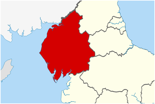
Most people are aware that the Lake District is located in the county of Cumbria.  However, not as many people know that the Lake District and Cumbria have quite different boundaries.  The Lake District is a national park and covers a smaller area within the wider county.  
The county of Cumbria highlighted in red.
Boundaries of the Lake District in green.

If you look at the maps above you will see that Cumbria stretches from Barrow-in-Furness and the peninsulas in the south, right up to the Scottish Border in the North.  It also covers the whole of the Irish Sea coastline in the west, and the M6 corridor to the east. The Lake District, on the other hand, does not include these areas, so the Cumbrian towns of Barrow, Ulverston, Workington, Whitehaven, Cockermouth, Kendle, Penrith and Carlisle fall outside the national park boundaries.

Cumbria also hosts the north western end of the Yorkshire Dales National Park.  Anybody who has driven up the M6 past the Kendal junction towards Penrith, couldn't fail to notice the impressive Howgill Fells looming up on the right hand side of the motorway. These fall within the boundaries of both Cumbria and the Yorkshire Dales, but not the Lake District itself.

The Howgill Fells as seen from the M6.


Thursday, 9 June 2016

Great North Swim

 Friday 10th June to Sunday 12th June 2016

Photo's taken from the Great North Swim website -
  http://www.greatrun.org/great-swim/great-north-swim

This weekend Lake Windermere hosts the annual Great North Swim.  It is a massive event taking place over 3 days with around 10,000 swimmer taking part.  There are various races of different distances - the longest being the 10k marathon swim, which is a new event introduced this year.  Entrants are expected to complete this race in around 4 hours! Other distances include the 1/2 mile, 1 mile, 2 mile, and 5k swims. 

Another new event introduced this year is the team relay.  This is three laps of the half mile course, with each participant swimming a full 1/2 lap before returning back down the home straight in front of the crowds to the transition area.

The event is based at the Low Wood Bay hotel located on the shores of Lake Windermere.  Due to the large scale nature of the event, there is likely to be significant travel congestion in the surrounding area.  This is worth bearing in mind if you were thinking of travelling on the A590/A591 between the M6 and Ambleside over the weekend.  If you are not taking part or spectating, it may be best to avoid the area.

Good luck to all the swimmers taking part!  Hope you all have a great day!